
Navigation is the art and science of knowing where you are, where you’re going, and how to get there safely. In aviation, navigation has evolved from dead reckoning with paper charts and magnetic compasses to satellite-guided precision approaches that can land aircraft in near-zero visibility conditions. For student pilots, understanding navigation systems is a required knowledge area. For aviation enthusiasts and frequent flyers, it’s a fascinating window into how modern aircraft always seem to know exactly where they are. This guide covers the full spectrum of aviation navigation—from classic ground-based navaids to cutting-edge satellite and data-link systems.
Pilotage and Dead Reckoning: The Fundamentals
Before electronics, pilots navigated by looking out the window and doing math. These two foundational techniques remain part of every private pilot curriculum—and for good reason.
Pilotage is visual navigation: identifying landmarks from the air and matching them to a chart. Railroad tracks, rivers, lakes, highways, towns, and distinctive terrain features serve as checkpoints. A pilot flying VFR cross-country will often use a combination of pilotage and compass headings to verify position. While it sounds primitive, an experienced pilot can navigate accurately across hundreds of miles using nothing but a sectional chart and sharp eyes.
Dead reckoning (DR) takes navigation a step further by using a known starting position, heading, airspeed, and time elapsed to calculate an estimated current position. The basic DR equation—distance = speed × time—is simple, but wind makes real-world DR more complex. Pilots use a flight computer (E6B) or electronic equivalent to calculate wind correction angles and true groundspeed, then estimate their position at any point along a route.
These techniques form the foundation of all navigation. Even pilots relying entirely on GPS are expected to understand DR, because GPS can fail, and situational awareness must never be dependent on a single system.
VOR Navigation: The Backbone of IFR Airways
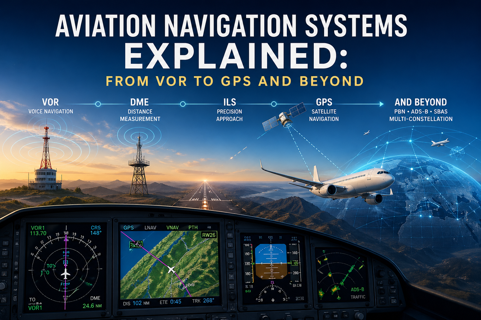
Very High Frequency Omnidirectional Range (VOR) stations have been the backbone of instrument navigation since the 1950s. Despite the rise of GPS, VORs remain widely used and legally required as a backup navigation system in many IFR environments.
A VOR ground station broadcasts 360 radials in all directions—think of them as magnetic compass bearings emanating from the station. Aircraft equipped with a VOR receiver can determine their position relative to any VOR station. The Course Deviation Indicator (CDI) in the cockpit shows whether the aircraft is left or right of the selected radial, while the OBS (Omni-Bearing Selector) knob lets the pilot choose any of the 360 radials.
VORTAC stations combine VOR navigation with TACAN (Tactical Air Navigation, a military system) to also provide DME (Distance Measuring Equipment) capability. DME gives pilots slant-range distance to the station, which combined with a radial defines an exact position called a “fix.”
The FAA’s VOR Minimum Operational Network (MON) program has reduced the total number of VORs in the National Airspace System, but strategically placed VORs will remain available as a GPS backup system. Pilots should maintain VOR proficiency, especially for IFR flying, as GPS anomalies and spoofing events—intentional or accidental GPS signal interference—are becoming more common.
ILS: The Precision Approach System
The Instrument Landing System (ILS) is the gold standard for precision instrument approaches, allowing aircraft to land in low-visibility conditions down to 200 feet ceiling and a quarter-mile visibility (and even lower with special equipment and procedures).
An ILS consists of two components: the Localizer provides lateral guidance (left/right of the runway centerline) on the approach, and the Glide Slope provides vertical guidance (typically a 3-degree descent path). The pilot flies an ILS approach by keeping both needles centered on the Course Deviation Indicator, descending smoothly until reaching the Decision Altitude (DA), where they either see the runway environment and land, or execute a missed approach.
ILS categories define the visibility minimums. Category I is the most common, requiring 200-foot ceilings and 1,800 RVR (Runway Visual Range). Category II requires 100-foot ceilings and 1,200 RVR, and demands special aircraft equipment and pilot certification. Category IIIa, IIIb, and IIIc approaches progressively reduce minimums, with Cat IIIc capable of zero-zero (zero ceiling, zero visibility) operations using autoland systems.
The ILS is both a technological marvel and a navigation fundamental. Understanding how to fly one is a gateway to the instrument rating and professional aviation.
GPS and RNAV: The Navigation Revolution
GPS (Global Positioning System) has transformed aviation navigation more profoundly than any technology since the invention of the radio. By receiving signals from a constellation of satellites, GPS receivers can determine position with extraordinary accuracy—typically within 3 to 5 meters for aviation-grade systems.
Area Navigation (RNAV) is a method of navigation that allows aircraft to fly on any desired path within coverage of navigation signals. GPS-based RNAV eliminates the need to fly directly over ground-based navaids, enabling more efficient routing, direct routings, and fuel savings across the NAS.
GPS approaches come in several flavors. GPS/LNAV (Lateral Navigation) approaches provide lateral guidance only, with a Minimum Descent Altitude (MDA) rather than a Decision Altitude. LPV (Localizer Performance with Vertical guidance) approaches use WAAS-augmented GPS to provide both lateral and vertical guidance with precision approach-like minimums—sometimes as low as 200 feet and 1/2 mile, comparable to a Category I ILS.
WAAS (Wide Area Augmentation System) is an FAA ground-based augmentation network that corrects GPS signal errors and provides integrity monitoring. WAAS receivers can achieve 3-meter horizontal accuracy and support LPV approaches at thousands of airports that lack an ILS.
RNP (Required Navigation Performance) takes RNAV further by specifying the accuracy the system must maintain and alerting pilots if that accuracy cannot be guaranteed. RNP AR (Authorization Required) approaches can fly curved paths into terrain-surrounded airports that were previously accessible only in visual conditions—a genuine lifesaver in remote mountainous regions.
ADS-B and NextGen: The Future of Aviation Navigation
The FAA’s NextGen program has modernized the National Airspace System through a suite of technologies, the most visible of which is ADS-B (Automatic Dependent Surveillance-Broadcast).
ADS-B Out—mandatory in most controlled airspace since January 1, 2020—broadcasts an aircraft’s GPS-derived position, altitude, speed, and identification to ATC and other aircraft. Unlike traditional radar (which sweeps every few seconds), ADS-B provides continuous, highly accurate position updates. ATC controllers see aircraft more precisely than ever before, enabling tighter spacing and more efficient traffic flow.
ADS-B In allows aircraft to receive traffic and weather information directly from the ADS-B network. Traffic Information Service-Broadcast (TIS-B) shows nearby aircraft on a cockpit display, dramatically improving situational awareness. Flight Information Service-Broadcast (FIS-B) delivers weather products including METARs, TAFs, and NEXRAD weather radar imagery—all for free, using an inexpensive ADS-B In receiver.
The combination of WAAS GPS, RNAV procedures, and ADS-B surveillance is enabling Performance-Based Navigation (PBN)—a global framework for defining navigation requirements in terms of performance rather than specific equipment. PBN is driving improvements in efficiency, safety, and capacity at airports worldwide, and understanding it is increasingly important for pilots operating in international airspace.