


When a winter storm threatens a major hub, waiting it out isn’t always the safest play. Here’s why Delta pulled its flights early and what it means for the 55,000 passengers caught in the middle.
When a deep low-pressure system began tracking toward the Twin Cities late last week, Delta Air Lines didn’t wait for the snow to start falling.
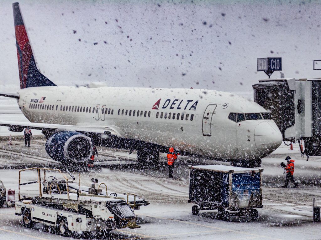
By Friday evening, the carrier had already begun trimming its schedule at Minneapolis–Saint Paul International Airport (MSP), and by Saturday morning, the scope of the disruption was clear: more than 480 flights canceled, roughly 65% of all planned Saturday departures gone, and over 55,000 passengers scrambling for alternatives.
It’s a move that looks dramatic from the outside. But inside the airline operations world, it’s increasingly recognized as the smarter play.
Why Delta Pulled the Plug Early at MSP
Minneapolis has long been one of Delta’s most critical northern hubs, connecting the Pacific Northwest to the Eastern Seaboard through a dense web of connecting itineraries. The airport is well-equipped for winter — its snow-removal fleet is among the most capable in the country. But there’s a hard ceiling to what any airport can handle, and this storm pushed well past it.


Forecasters were calling for 12 to 18 inches of snow within a 24-hour window, with peak wind gusts recorded at 42 mph at field elevation. The final tally came in around 14.5 inches for the Twin Cities corridor. That’s not a typical Minnesota snow day. That’s a scenario where even the best ground crews can’t keep pace.
The meteorology driving this particular storm made things worse. A Gulf moisture feed collided with a polar air mass — a combination that produces what forecasters call “heavy wet snow.” Unlike the dry, powdery snow MSP handles routinely, heavy wet snow is denser, accumulates faster, and clings to aircraft surfaces in ways that complicate de-icing significantly.
The Science Behind the Decision: Hold-Over Time
Here’s a concept most travelers have never heard of that shapes almost every cancellation decision in a winter storm: hold-over time, or HOT.
When a plane is de-iced, the fluid applied to its wings remains effective for only a limited window before it needs to be reapplied. In light snow or freezing drizzle, that window might be 20 to 30 minutes. When snowfall rates exceed an inch per hour — as they did at MSP this weekend — that window can collapse to under 10 minutes.
What this means in practice: an aircraft that gets de-iced may need to return for a second application before it even reaches the runway. In a high-frequency hub environment where 400-plus Delta departures are scheduled on a normal day, that creates a cascading bottleneck that no amount of equipment can solve. The math simply stops working.
Delta’s Integrated Operations Center in Atlanta, which manages the entire network, made the call to thin the schedule before the storm peaked precisely to avoid that bottleneck.
What MSP’s Runway Layout Has to Do With It
The storm’s wind direction added another layer of complexity. When strong north-northwesterly winds take hold at MSP — which they did this weekend — the airport is typically restricted to its parallel runway pair (12L/30R and 12R/30L). That restriction, combined with the need to pull at least one runway offline at any given time for continuous snow plowing, effectively halved available takeoff and landing capacity.

For an airport handling Delta’s volume, a 50% runway reduction doesn’t translate to 50% fewer flights. It means the queue builds faster than it clears — and once you’re in that situation, recovery takes days, not hours.
The Ripple Effect: Detroit, Salt Lake, and the National Network
MSP doesn’t operate in isolation. Every aircraft that can’t depart Minneapolis is an aircraft that can’t show up in Detroit, Salt Lake City, Boston, or wherever its next leg was scheduled to take it. Crew members accumulate duty hours waiting on the ground. Aircraft fall out of position for the next day’s flying.
By executing a controlled shutdown early, Delta retained what operations teams call “spare” capacity — aircraft positioned in warmer climates, crews with clean duty records, ready to execute an accelerated restart once the storm clears Sunday.
That recovery phase is already the focus now. Analysts and travelers alike should expect high load factors on Sunday and Monday flights as the airline works through its passenger backlog, potentially deploying larger aircraft or adding extra “sweeper” flights to absorb the overflow.
Regional Partners Took the Brunt First
Delta Connection carriers — SkyWest and Endeavor Air — felt the impact before mainline Delta flights did. Regional jets, which operate smaller airframes with tighter crosswind tolerances, are routinely the first to be grounded during winter events. Of the 482 total cancellations logged as of Saturday noon UTC, regional operations accounted for roughly 40%.
This tiered grounding strategy is intentional. By protecting capacity on larger, long-haul and transcontinental aircraft, Delta maximizes the movement of the most passengers per available window of safe flying conditions. It’s a triage approach: smaller planes, smaller passenger loads, and smaller cross-wind envelopes come off the schedule first.
What This Means If You’re One of the 55,000
Delta has been routing rebooking traffic through its Fly Delta app rather than phone lines and gate agents during this disruption — a shift that reflects how the airline has redesigned its disruption response over the past several years. For most affected passengers, rebooking notifications arrived before they left for the airport, which is the whole point of the proactive cancellation strategy.
Rather than waiting inside a terminal for a flight that gets canceled at the gate, passengers received digital notification of the disruption, a rebooking option in the app, and in most cases, enough lead time to make alternative arrangements. It doesn’t make the disruption painless — but it does reduce the tarmac delay fines, hotel voucher costs, and terminal overcrowding that characterized airline winter responses a decade ago.
The Bigger Picture for Airline Operations
This weekend’s MSP disruption is a useful case study in how modern carriers have restructured their approach to severe weather. The old model was reactive: cancel flights as conditions deteriorated, deal with the congestion and crew positioning fallout afterward. The current model is predictive: use 48-hour forecast data to model network impact, execute a controlled reduction, and protect the system for a faster restart.
United’s Chicago O’Hare hub, which saw only minor delays during the same weather period due to the specific track of the low-pressure system, offers a useful contrast. Same storm system, very different operational outcome — because track and timing determine which hub takes the hit.
As the storm continues its eastward progression toward the Great Lakes, Delta’s contingency planners are already evaluating similar protocols for its Detroit hub. Whether DTW needs the same kind of proactive thinning will depend on exactly where the system’s heaviest precipitation bands track over the next 12 hours.
For now, the recovery clock at MSP is running.